
Method

The CLIMB method for quantifying biodiversity

CLIMB is a metric for calculating biodiversity in Nordic nature. Biodiv is built on CLIMB and turns the method into a digital workflow.

What is CLIMB?

Changing Land Use Impact on Biodiversity

CLIMB is a model for calculating biodiversity within geographically defined areas and for assessing change when land use changes. The model is used to calculate the baseline, negative impacts and positive impacts, and expresses results in CLIMB units (CU).

CLIMB was developed for Nordic conditions and is used in energy, extractive industries, infrastructure and urban development to make better-informed decisions on land use, compensation and reporting.
Background

Open source with broad industry backing

CLIMB was developed by 11 major companies and industry organisations in a joint industry initiative and launched as open source in autumn 2023.

The model builds on the Swedish standard for nature value assessment (SIS SS 199000) and is based on the UK Defra Biodiversity Metric 3.0, with parameters adapted to Swedish and Nordic nature.

It was developed by an expert team together with an Advisory Board (2022–2023) of researchers and specialists, combining a sound scientific basis with practical applicability for business.

CLIMB logo

Applications

When is CLIMB used in practice?

Quantify baseline and change

Calculate biodiversity before and after a change in land use, using the same logic.

Compare alternatives and scenarios

Support for evaluating different locations and designs based on their nature impact.

Restoration and compensation

Avoid and minimise impacts, plan measures and track the net effect in CU.

Reporting and KPIs

Create measurable indicators and clearer decision support for your organisation and stakeholders.

Process

How a CLIMB calculation works

CLIMB divides the work into an impact area (the project) and, where needed, a compensation area (measures outside or in addition to the intervention). The same logic applies to both.

Impact area

  1. The project area is delineated (e.g. a detailed development plan, a mine, a power line corridor).
  2. NVI according to SS 199000:2023 → nature value classes.
  3. Baseline calculation → CU (based on e.g. nature value class and valuable landscapes).
  4. Change calculation → future CU after the planned measures.
  5. The total shows the loss or gain in CU.

Compensation area

If an intervention results in a CU loss, a separate area can be modelled using the same steps. The model takes into account the distance and biogeographical region between impact and compensation, and measures must be additional.

Read more about ecological compensation with CLIMB

Five outcomes in the change calculation

For each biotope, the calculation shows how the area is affected – this is the basis for gains and losses in CU:

Enhanced – restoration measures that raise the nature value.

Lost – direct intervention (road, open-pit mine, felling, etc.).

Degraded – impacts that lower the nature value without a complete loss.

Retained – area that is kept intact.

Created – a new habitat type that did not exist before.

For enhancement and creation, risk factors are also taken into account (e.g. the time and difficulty of reaching the target habitat type). Full method description: climb.ecogain.se/metod.

Mitigation hierarchy

Avoid, minimise, restore, compensate

CLIMB supports the internationally recognised four-step approach: avoid impacts (e.g. through a different location), minimise impacts where they still occur, build restoration into the project, and compensate for the remaining loss – sometimes with a net positive effect. According to the CLIMB method, the model enables calculations across every step of the mitigation hierarchy.

The handbook, technical description and KPIs for each use case are available at climb.ecogain.se (the model has been open since the project concluded in September 2023).

Environmental permitting

CLIMB in permits and in court

Since CLIMB was launched in autumn 2023, the model has been used in environmental permitting and has led to clearer permit conditions. The Swedish Land and Environment Court has in several cases based compensation on CLIMB – for example requiring measures to correspond to at least 115% of the impact value calculated using CLIMB or a similar model (M 1573-20). The Swedish Environmental Protection Agency has highlighted the value of the model's systematic assessments (e.g. M9227-23).

The CLIMB method · Read more about 115% and case law (in Swedish) · Environmental permitting with Biodiv

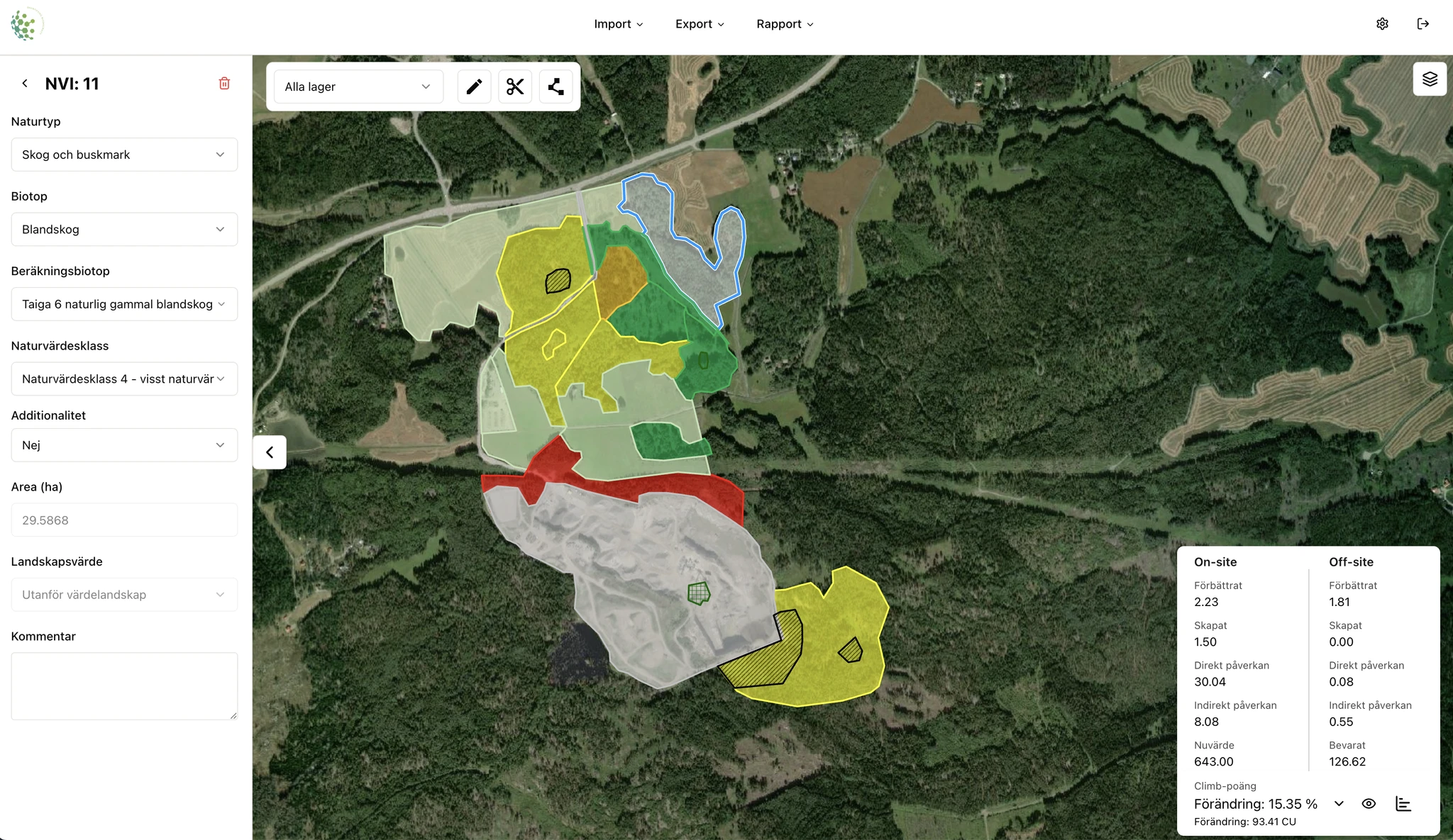
Biodiv's map-based CLIMB workflow

Biodiv + CLIMB

How Biodiv makes CLIMB easier to use

  • • Makes CLIMB accessible to more people than those willing to work manually across several Excel sheets.
  • • A map-based workflow that matches how teams already work in GIS and project design.
  • • Faster scenario comparisons and clearer communication of losses and gains.
  • • Lets you start CLIMB even with older NVI data that lacks calculation biotopes – see our NVI article (in Swedish).
  • • Processes that used to take weeks can often be completed in half a day.

"CLIMB became understandable for the whole project team once we could visualise the results in the same workflow."

Environmental specialist
energy company

FAQ

FAQ about CLIMB

Quick answers about the method, its applications and how Biodiv digitalises the work.

What does CLIMB stand for? +

CLIMB stands for Changing Land Use Impact on Biodiversity.

What is CLIMB used for? +

CLIMB is used to quantify biodiversity, compare alternatives, assess the impact of land use and support decisions on mitigation, restoration and compensation.

How does Biodiv relate to CLIMB? +

Biodiv digitalises CLIMB work in a map-based workflow, so teams can go from NVI to calculation, scenario comparison and reporting faster.

What are CLIMB units (CU)? +

CU (CLIMB units) is the model's unit for comparing baseline, impacts and measures. Read more in our article on CU (in Swedish).

How does CLIMB relate to CSRD and ESRS E4? +

ESRS E4 is about accurate and transparent reporting of impacts on nature. CLIMB provides baselines, change and monitoring in CU. See sustainability reporting with Biodiv.

Is CLIMB used in court? +

Yes, the Swedish Land and Environment Court has in several cases set conditions based on CLIMB, e.g. compensation of at least 115% of the impact value. Read more (in Swedish).

What is the difference between the impact area and the compensation area? +

The impact area is where the project changes the land use. The compensation area is where additional measures are modelled to balance the CU loss – taking into account the distance and region between the areas.

What do enhanced, lost, degraded, retained and created mean? +

They are the five outcomes in the CLIMB change calculation for each biotope. Together they determine future CU and the net effect. See the method description.

Where can I read more about CLIMB? +

The full method, user handbook and technical description: climb.ecogain.se/metod. Biodiv's workflow: the platform.

Explore the original CLIMB source

Method, handbook and technical description at climb.ecogain.se – including the mitigation hierarchy and compensation.